The Historic Atlas of York: 2,000 Years of Urban Development
Speaker: Dr Peter Addyman
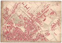
 An Ordance Survey map of York in 1851. 09 OS Map 1851
- Sunday 16 June 2013, 2.00PM to 3:00pm
- £4. To book a place, please contact exploreyork@york.gov.uk or book online through the Inspire website.
Book tickets - Explore York Library Learning Centre, Museum Street, YO1 7DS (view map)
Event details
Ticketing: £4. To book a place, please contact exploreyork@york.gov.uk or book online at www.feelinginspired.co.uk.
The Historic Atlas of York, now nearing completion, will trace the urban development of York from Roman times to the present, identifying every street and named structure accompanied by a sheaf of illustrations and reproductions of early maps.
In this talk Dr Peter Addyman will bring to life a redrawn version of the 1850’s Ordnance Survey map of York which forms the base map for the historic atlas to present an overview of the urban development of the city of York.
Speaker biography
Dr Peter Addyman, an Archaeologist, founded York Archaeological Trust in 1972 and was its director for 30 years. He is currently Chairman of York Civic Trust and President of the Yorkshire Philosophical Society.
For much of his retirement Peter has been working with a team of academic colleagues to produce the York volume of the international Atlas of Historic Towns.
Website: www.feelinginspired.co.uk

