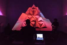
Space F!ght: Audio Visual Experience of Ozone Data
Howard Cambridge, Dr Radoslaw Rudnicki, James Mainwaring, Anna Edgington, Jakub Hader, Dr Patrick Bueker
 © Weronika Czarniecka
- Friday 13 June 2014, 6.30PM to 7.15pm
- Free admission
Booking required - Ron Cooke Hub, University of York (map|getting to campus)
Event details
![]()


This audio-visual show contains a piece made in collaboration with researchers from Stockholm Environment Institute (SEI) and NASA’s Goddard Institute for Space Studies (GISS).
In this piece satellite ozone data controls the improvisation and 3D visualisations. Space F!ght is using ground level ozone data, which is the best representation of the ozone that harms human health. Since Ozone’s impact is all about location, Space F!ght is using the data from different locations around the globe with diverse level of ozone concentration; representing the ozone data rather than culture or any other characteristic of the locations. To represent each place average monthly ozone concentration is used in a time series of 12 months. The 45-minute show will be followed by a 15-minute discussion and Q & A session.
Those interested to find out more about the impacts of ozone are recommended to read the ‘Integrated Assessment of Black Carbon and Tropospheric Ozone‘, an international study that was co-ordinated by SEI and chaired by Dr Drew Shindell of NASA GISS.
The report was one of the key documents that lead to the establishment of the Climate and Clean Air Coalition (CCAC) in 2012.
Attendees may also be interested in attending SoniHED - Conference on Sonification of Health and Environmental Data at the Department of Theatre, Film and Television, University of York on 12 September.
Related Links:
Follow @Radek_Rudnicki on Twitter
Accessibility
![]()
Wheelchair accessible
Tickets
You may also like...
This event is part of the Science out of the Lab festival theme. Also in this theme:

